The San Patrick SOS
December 17, 1964 — Six hours of distress in the North Pacific
On December 17, 1964, at 06:42 (Alaska time), the San Patrick began transmitting distress signals from the vicinity of the Aleutian Islands. For more than six hours, Radio Officer Antonio Herrero Monsalve kept communication with the Japanese merchant vessel TETSUKO MARU, then on its way to Yokohama.
The communications, growing more desperate by the hour, are the only testimony of the final moments of the 32 crew members. At 12:59, the signal went silent for good.
A note on times
All times in this chronology are given in Alaska Standard Time (AKST), UTC-9. To convert to Spanish time (CET, UTC+1), add 10 hours.
Example: 06:42 AKST = 16:42 in Spain.
Chronology of communications
Transcript of the communications between the San Patrick (call sign AG2JUT) and the TETSUKO MARU, according to US Coast Guard records.
First SOS
The San Patrick transmits its first distress signal. Reported approximate position: 51°20′N 179°40′W. Requests a tow, aground bow-first.
TETSUKO MARU acknowledges
The Japanese merchant vessel TETSUKO MARU (ore carrier, 17,094 tons) receives the signal and acknowledges with code RRR.
San Patrick confirms critical situation
The San Patrick confirms the ship is sunk and asks how long until assistance arrives.
Position uncertain
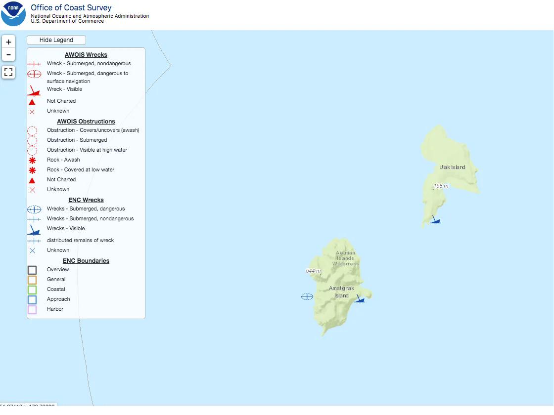
The San Patrick reports that it does not know its exact position. Believes itself to be between Ulak and Amatignak Islands.
New position transmitted
A new position is transmitted: 51°20′N 179°05′W. This position will also prove erroneous.
TETSUKO MARU establishes radio bearing
The Japanese vessel manages to establish the actual position of the San Patrick using its direction finder: bearing 92°.
Desperate situation
The message turns urgent. A lifeboat is requested without delay.
DESPERATE SOS
The message reaches its peak of desperation. No power, only the receiver battery.
Last voice message
The last message transmitted by voice. After this, only Morse.
LAST SIGNAL
The TETSUKO MARU receives only Morse signals. From this moment on, all communications go unanswered. The final DF bearing is 151°.
The silence on the radio marks the end of all contact with the 32 crew members of the San Patrick.
Gaps in the documentation
The transcript of the communications we hold contains gaps and inconsistencies. There are intervals with no record at all, and some messages are partially unintelligible in the original US Coast Guard documents.
A request has been made to the Embassy of Japan in Spain for the possibility of obtaining the complete documentation and the official reports of the TETSUKO MARU, which was the only direct witness to the San Patrick communications during those six hours. This documentation could provide crucial information about the messages exchanged and the rescue efforts undertaken.
Status of the request: Awaiting reply (request submitted in 2024).
The search (December 18-23, 1964)
December 18-19
A violent storm prevents reconnaissance flights. The TETSUKO MARU circles the islands without managing to locate the wrecked vessel.
December 20
A US Navy aircraft from the Adak base finally locates the wreck at 51°18.7′N 178°57.8′W. The hull lies broken against the cliffs of Ulak Island.
A US Navy helicopter locates the hull of the San Patrick and observes from 500 ft altitude the ocean breaking through the central section. The bow is bent over the upper part of the cliff.
December 20-23
A search for survivors is carried out, with negative results. The US Coast Guard cutter USCGC TAWAKONI inspects the area.
December 23
Significant findings:
- A line-throwing gun is found firmly anchored at the top of the cliff, with 200 metres of line laid out toward the ship. This indicates that someone managed to reach land.
- 3 bodies are sighted in the vicinity of the wreck.
- Only one is recovered: that of Radio Officer Antonio Herrero Monsalve.
- The other two bodies are left behind on the grounds that their recovery is "too dangerous".
- The bodies are stripped of clothing and covered in grease.
December 25
The tug MINARES reports a light shining on the horizon, which disappears as the vessel heads in its direction. An aircraft from Adak takes off in search of the light but finds nothing.
This light was never explained. Survivors trying to signal? A natural phenomenon? The mystery remains.
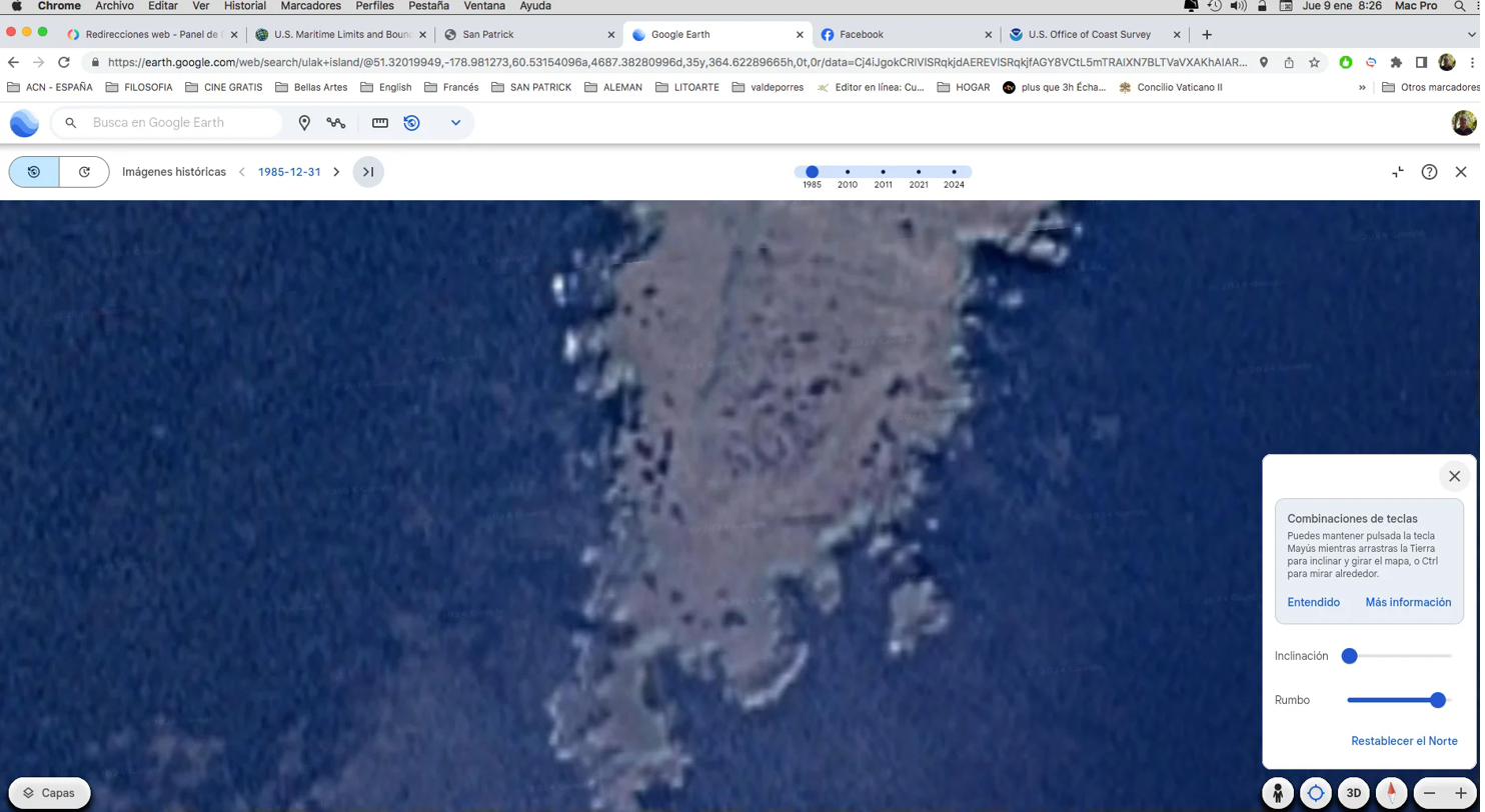
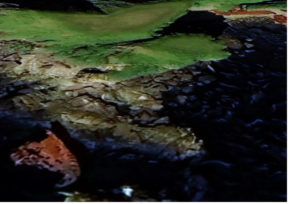
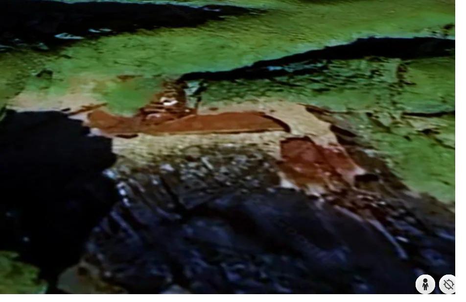
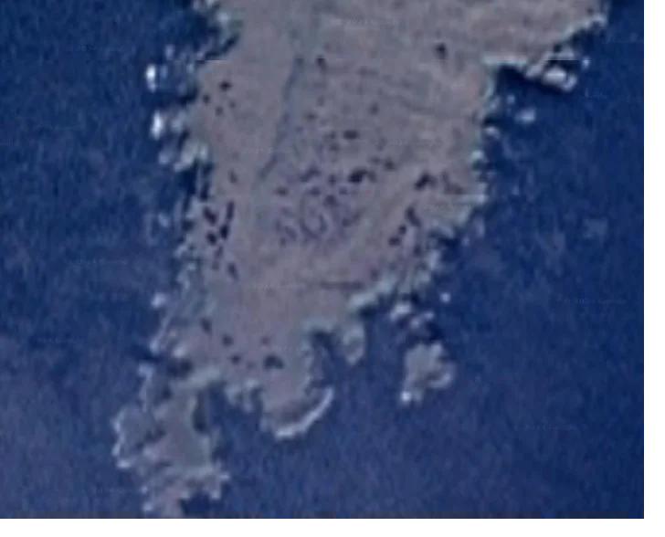
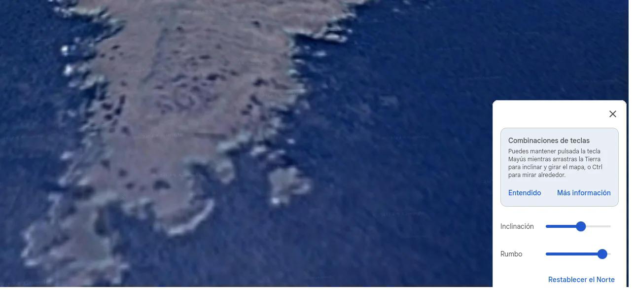
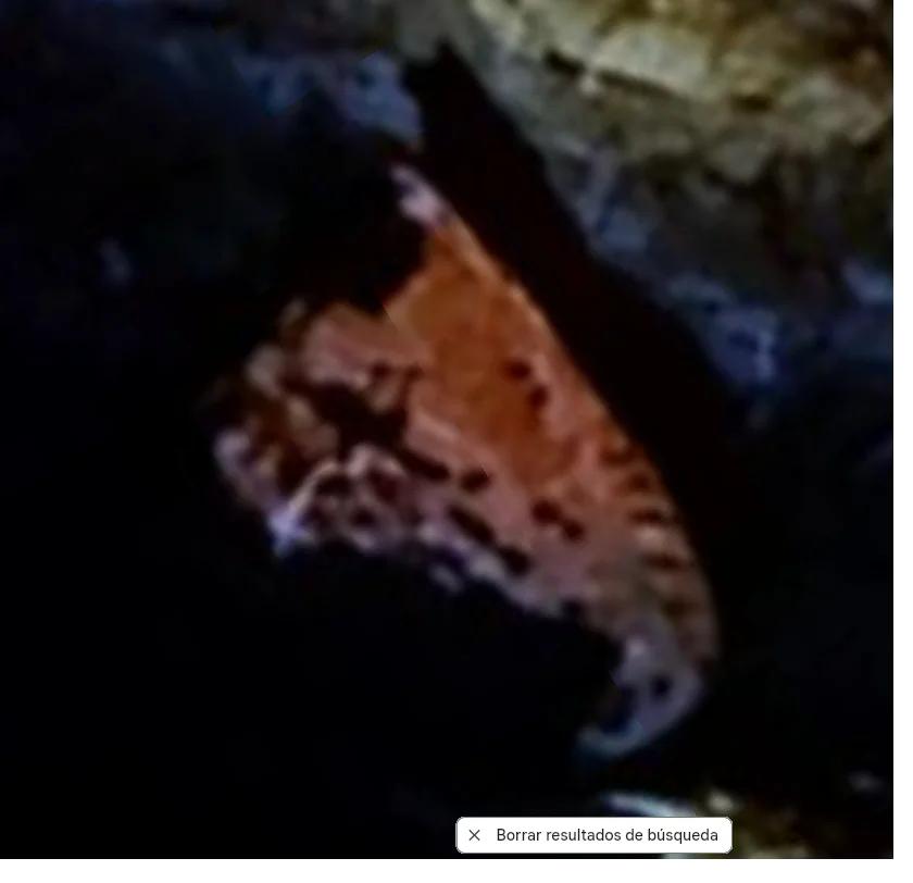
The mysterious SOS of Ulak Island
In the course of the investigation, while reviewing historical satellite imagery on Google Earth, a discovery was made that could change everything we know about this wreck.
The discovery
While going through the historical satellite imagery of Ulak Island (available from 1985 onward), in the photographs from December 1985 —21 years after the wreck— the word SOS appeared clearly visible, in strong relief on the rocks, in the centre of the islet and very close to the site of the wreck.
Satellite imagery — Google Earth
Nautical chart — NOAA Office of Coast Survey
The implications
If the SOS visible on the islet is genuine and not the product of a visual confusion or a natural geological formation, we would be facing a dramatic scenario:
- There were survivors who managed to reach land after the wreck.
- These survivors had the capacity and the time to build a distress signal visible from the air.
- The signal remained visible for at least 21 years (until 1985, the date of the first available satellite image).
- This would confirm the families’ long-held suspicions of a deficient or non-existent rescue.
Unanswered questions
- Why was no rescue team sent to inspect the interior of the ship and its surroundings in search of survivors?
- Why were the two sighted bodies not recovered, on grounds of "danger"?
- What was the light sighted on December 25 by the tug MINARES?
- Why did the United States deny the families access to the wreck area without any explanation?
- Is this refusal connected to the secret nuclear tests being prepared on the nearby island of Amchitka?
Investigation in progress
Actions taken
| Action | Recipient | Status |
|---|---|---|
| Request for rescue reports | US Coast Guard District 17 (Juneau, Alaska) | No response |
| Request for TETSUKO MARU documentation | Embassy of Japan in Spain | Pending |
| Access to declassified records | NARA (National Archives) | Preliminary response |
| Expert image analysis of the SOS | Pending identification of expert | Not started |
How you can help
If you have information, documentation or expertise that may contribute to this investigation, please get in touch:
- Email: jjgd@litoarte.com
- Project email: noticias@sanpatrick.eu
We are particularly looking for:
- Documentation of the TETSUKO MARU or its shipping company
- Unpublished US Navy or Coast Guard reports
- Testimony from personnel stationed at Adak in 1964
- Experts in satellite image analysis
- Information about activities in the Aleutian Islands in December 1964