The Amchitka Secret
Underground nuclear tests in the Aleutian Islands (1965-1971)
The island of bombs
Amchitka is an island located at the western end of the Aleutian Islands, approximately 1,340 miles west-southwest of Anchorage, Alaska. It forms part of the Aleutian Islands National Wildlife Refuge.
Between 1965 and 1971, the United States Government carried out three underground nuclear tests on this remote island, in the midst of the Cold War. Ulak Island, where the San Patrick was wrecked, lies less than 100 miles from Amchitka.
The underground cavities of the three detonations remain radioactive. No viable remediation technology exists.
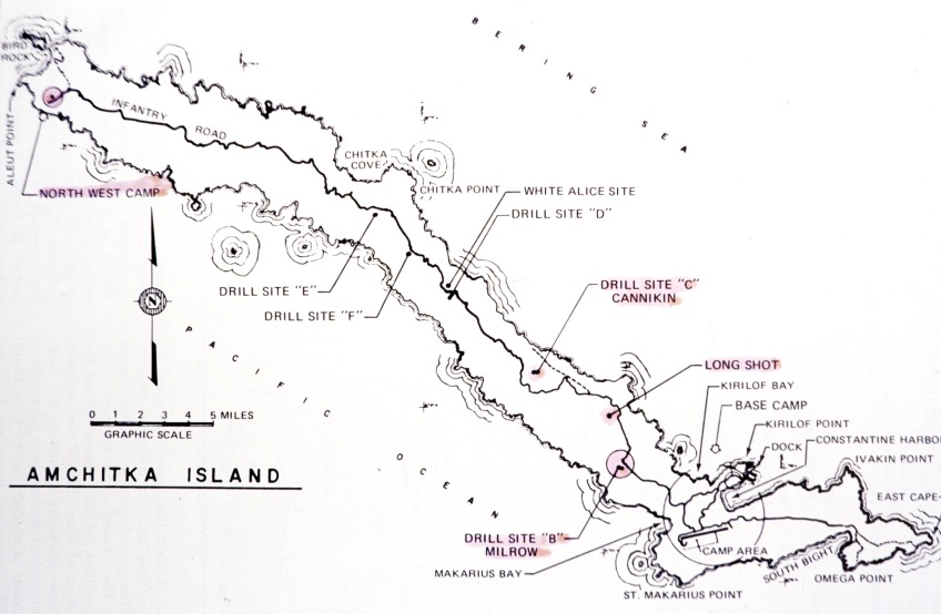
Map of Amchitka Island showing the drill sites: Long Shot, Milrow (Site B) and Cannikin (Site C)
The nuclear facilities
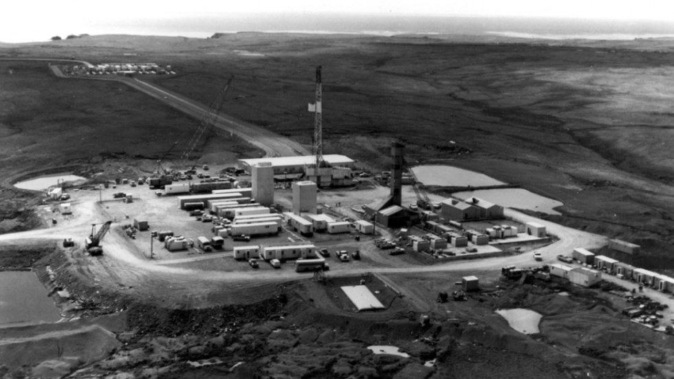
Drilling tower and base camp for the underground nuclear tests
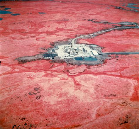
Aerial infrared view showing the facilities on the Amchitka tundra
The three nuclear detonations
| Name | Date | Yield | Depth | Seismic magnitude | Purpose |
|---|---|---|---|---|---|
| LONG SHOT | October 29, 1965 | 80 kilotons | 701 m | Mb 6.1 | Vela Uniform program (explosion detection) |
| MILROW | October 2, 1969 | ~1 megaton | 1,218 m | Mb 6.5 | Calibration test for a larger device |
| CANNIKIN | November 6, 1971 | <5 megatons | 1,792 m | Mb 6.8 | Weapons test (the largest in the U.S.) |
Yield comparison
Long Shot (1965)
The first nuclear test at Amchitka was part of the Vela Uniform program, designed to improve the United States’ ability to detect underground nuclear explosions and distinguish them from natural earthquakes.
Preparation
- The first drilling rig arrived on May 13, 1964
- 6 exploratory wells were drilled (the deepest at 879 m)
- Main shaft: 72 inches in diameter to 20 m, then 54 inches to 715 m
- Completed and sealed on October 2, 1965
Environmental impact
- 81 geophone detectors buried
- 2,500 tons of explosives in prior tests
- 8,000 cubic yards of material extracted
- Main concern: the sea otters
“La mayor preocupación, con diferencia, es con las nutrias marinas. Las pesquerías, leones marinos y aves son de importancia secundaria.”
— Estudio de seguridad bioambiental, Universidad de Washington
“The greatest concern, by far, is with the sea otters. Fisheries, sea lions and birds are of secondary importance.” — Bioenvironmental safety study, University of Washington
[Translated from Spanish; original English wording unconfirmed]
Milrow (1969)
The second test was a calibration test to determine whether the geology of Amchitka could withstand a much larger explosion. It was a necessary preliminary step to Cannikin.
The detonation generated a magnitude 6.5 earthquake and caused ground disturbances in localized areas of the island.
Cannikin (1971) — The largest test
Cannikin was the most powerful underground nuclear test ever carried out by the United States. It was detonated on November 6, 1971, at almost 1,800 metres in depth.
Consequences
- The detonations produced scattered ground disturbances around the island, some severe in localized areas
- The landscape was visibly altered and may remain so for decades or even centuries
- The fission products from the three tests remain in the underground cavities
- Tritium has been detected in groundwater near the Long Shot site (declining over time)
Current situation
The U.S. Department of Energy (DOE) has maintained a Long-Term Surveillance Plan for Amchitka since 2008.
Monitoring
- Inspections in 2006 and 2011
- Sampling of 14 marine species
- Radioisotope analysis
- Groundwater monitoring
No known remedy
The underground cavities of the three tests remain radioactive. No viable remediation technology has been identified for the radioactivity that remains in the deep subsurface.
In January 2007, the Alaska Department of Environmental Conservation accepted the DOE report, declaring that “no further remediation action is required” beyond long-term surveillance.
The connection with the San Patrick
The wreck of the San Patrick occurred on December 17, 1964, less than a year before the first nuclear test (Long Shot, October 1965).
Unanswered questions
- Why did the United States deny the families access to the wreck area?
- Did the secret nuclear preparation activities affect the management of the rescue?
- Were there military personnel in the area who could have helped with the search efforts?
- Why were two of the three sighted bodies abandoned?
The temporal and geographical proximity between the wreck and the nuclear tests adds a further layer of mystery to an event already full of unanswered questions. The area was being prepared to become one of the most secret sites in the U.S. nuclear program.
Documentary sources
- Kohlhoff, Dean W. (2002). Amchitka and the Bomb: Nuclear Testing in Alaska. University of Washington Press.
- U.S. Department of Energy (2014). Amchitka Long-Term Surveillance Plan. Doc. No. S01980-1.0.
- Merritt, M.L. & Fuller, R.G. (1977). The Environment of Amchitka Island, Alaska. U.S. Energy Research and Development Administration.
- O’Neill, Dan (1994). The Firecracker Boys. St. Martin’s Press.